

Barrhaven – Discover it today!
Barrhaven is a rapidly growing surburban neighbourhood in the southwest area of the city. It is approximately 17 km (11 mi) southwest of downtown Ottawa. Barrhaven is now a beautiful, booming ‘suburb’, the most rapidly growing area of the city. It is a thriving community, with bountiful family and neighbourhood resources. Close to shopping, recreation, schools etc. Two new shopping centres at the junction of Strandherd and Greenbank, as well as smaller lifestyle centres spread throughout the area make Barrhaven a prime shopping destination. Barrhaven has it all!
School Information
Elementary – Public schools
Intermediate – Public School
Secondary Schools – Public
Elementary – Catholic schools
Secondary Schools Catholic
Private schools
Churches
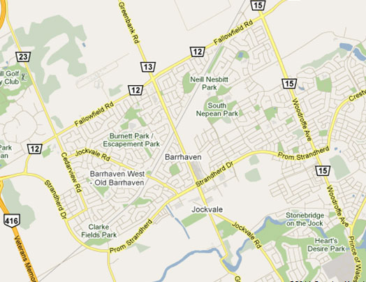
Neighbourhoods of Barrhaven:
Barrhaven is divided into many neighbourhoods. The names are generally selected by developers.
- Barrhaven, also known as Old Barrhaven, west of Greenbank, south of Fallowfield, north the of rail tracks, and west of Jockvale
- Strandherd Meadows, the infill development extending Old Barrhaven to Strandherd Drive
- Longfields, east of Greenbank Road, west of Woodroffe Avenue, south of Fallowfield Road and north of Strandherd Drive
- Davidson Heights, east of Woodroffe Avenue
- Havenlea, bounded by Crestway Drive, Leikin Drive, Prince of Wales and Cresthaven Drive
- Chapman Mills, bounded by Prince of Wales Dr to the south/east, Woodroffe Ave to the west, and Stoneway Dr to the north.
- Rideau Glen, along Prince of Wales Dr, Holborn Avenue, and Rideau Glen Drive, north of Winding Way
- Winding Way, east of Prince of Wales Drive
- Stonebridge, located between Jockvale Rd and Prince of Wales
- Half Moon Bay, new neighborhood under development along Cambrian Road, west of Greenbank, east of Highway 416, south of the Jock River and north of Barnsdale Road
- Barrhaven Mews, new community under construction between Strandherd Road and the Jock River and west of Jockvale/Greenbank Roads
- Barrhaven on the green, located between Jockvale Road, Greenbank Road, Strandherd Road, and the Rail tracks
- Havenlea, east of Woodroffe Avenue, south of Crestway Drive
- Hearts Desire, located along the Jock River, in between Jockvale Road and Woodroffe Ave.
- West Pointe Village, located between Cedarview Rd., Fallowfield Rd., Strandherd Rd., and the Rail tracks
- Pheasant Run, west of Larkin Drive, south of Fallowfield, north of Jockvale and east of Cedarview Road
- Fraservale, south and west of Jockvale, east of Cedarview and north of rail tracks
- Knollsbrook, west and north of rail tracks, south of Fallowfield and east of Greenbank.
Transportation Access
OC Transpo express commuter buses connect Barrhaven to downtown Ottawa in the morning and in the afternoon, and there is an all day bus service to the major shopping centres in Ottawa. Barrhaven is served by seven local bus routes: 170, 171, 173, 175, 176, 177 and 186. These routes serve the local roads of Barrhaven as well as serving Fallowfield Station and Strandherd Station, where a transfer can be made to Ottawa’s Rapid Transit system with Route 95. There are five express bus routes, 70, 71, 73, 76, and 77, that provide direct service to downtown Ottawa during the morning rush hour and from downtown during the afternoon rush hour.
Visit: OC Transpo for more information.
Miscellaneous
For more information on Statistics and Economic Profile: Barrhaven|City of Ottawa